
Media Intelligence / Applied video analysis
What can a few seconds of video tell us about motion?
From imperfect footage to measurable evidence. A frame-by-frame study of projected motion, with the method, assumptions, and limits kept in view.
Explore the evidence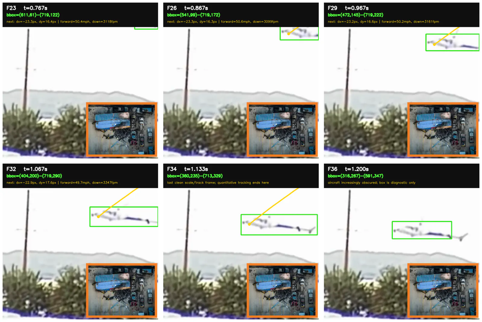
Projected forward component
Approximately 44 kt across the image plane. Forward uncertainty: ±20%.
Average image-plane descent
The report’s conservative video-based estimate; not an impact rate.
Last clean vertical interval
F33 → F34 only, before the aircraft is substantially obscured.
These are projected two-dimensional measurements. They do not establish true airspeed, three-dimensional velocity, or accident cause.
01 / THE ANALYTICAL APPROACH
Measure the motion. Preserve the evidence.
The question is how much visible movement can be quantified from a short, uncalibrated video. ContextFormers isolates the aircraft, tracks coherent features, and converts their displacement using a physical reference that matches the image.
Select
Use the clean real-time pass. Exclude replay and heavily occluded frames.
Detect
Subtract a stationary background to locate the moving aircraft.
Track
Validate coherent feature motion in both forward and backward directions.
Scale
Match the marked nose-to-tail span to the published fuselage length.
Convert
Calculate projected physical motion and compare it with external data.
Source footage and measurement scopeTwo copies · one camera feed · F23–F34
51426c028307e330513d4af9f42784a1974045c8.mov and c7eaffaf811a4c8eb1fa665753bcc470.MOV.mov. Both report approximately 30 frames per second. The first file provides the cleaner geometry used for quantitative measurement; the second is the same camera feed in a wider, screen-recorded framing and contains a later labeled slow-motion replay. It is a consistency check, not an independent viewpoint.
| Source copy | Metadata | Analytical role |
|---|---|---|
| Square copy | 720 x 720 | 644 frames | 21.467 s | Primary F23-F34 tracking and scale |
| Wide copy | 910 x 512 | 606 frames | 20.200 s | Same-camera consistency check; replay excluded |
ContextFormers performed a frame-by-frame computer-vision analysis of the real-time footage. We estimate a projected forward groundspeed of approximately 50 miles per hour, or 44 knots, and an image-plane descent of at least about 3,200 feet per minute, increasing to approximately 3,420 feet per minute in the last clean interval. Public flight-tracking data reported 4,160 feet per minute at 01:55:19 UTC and 4,800 feet per minute in the final sample, with a final groundspeed of 39 knots. Because those samples are not frame-synchronized to the supplied video and the camera view compresses three-dimensional motion, 3,200 feet per minute should be presented as a conservative video-based estimate, not an exact descent or impact rate.
Frames F23 through F34 of the clean real-time pass, corresponding to 0.767 through 1.133 seconds within that edited clip. The slow-motion replay and frames after substantial overlap with the treeline were excluded from the primary calculation.
The second supplied file carries the 'Via @CopterPilot' credit and the labeled regular-speed and slow-motion sequence described in contemporary coverage of the 15 September 2026 Chatsworth, Los Angeles news-helicopter crash. Telemundo 52 identifies that event as the NewsChopper4 crash, and Flightradar24 identifies the aircraft and flight data as N358TV. The registration and flight data used in this report are therefore tied to this specific event. No historical AS350 accident record is used in the calculations or comparison.
02 / FRAME-BY-FRAME EVIDENCE
A visible sequence. A bounded measurement.
The usable interval ends where the scene stops supporting reliable tracking. Diagnostic boxes locate the moving region; the box corners are not the velocity measurement.
Entry & tracking
Cabin features are visible as the tail enters the frame. A coherent moving cluster supports optical-flow measurement.
Complete profile
The aircraft follows a steady diagonal path. F34 provides the most complete clean nose-to-tail reference.
Occlusion boundary
Vegetation increasingly overlaps the aircraft. These frames are excluded from primary speed and impact claims.
Inspect the complete frame-by-frame observationsF23–F38 · visibility and analytical use
| Frames | Time | Direct observation | Analytical use |
|---|---|---|---|
| F23-F25 | 0.767-0.833 s | Nose and forward cabin enter from the right; much of the tail remains outside the image. | Tracking starts on visible cabin features. |
| F26-F28 | 0.867-0.933 s | Nose, cabin, mast region and more of the tail boom form a coherent profile. | Clean optical-flow displacement; far tail remains near the edge. |
| F29-F31 | 0.967-1.033 s | Nearly the complete side profile is visible and follows a steady diagonal path. | Forward component remains near 50 mph; descent is about 36-38 mph. |
| F32-F34 | 1.067-1.133 s | The most complete aircraft profile is visible; F34 gives the best nose-to-tail scale. | Primary scale frame and final clean speed interval. |
| F35-F36 | 1.167-1.200 s | The aircraft approaches and begins overlapping the lower background and vegetation. | Diagnostic boxes only; no primary speed claim. |
| F37-F38 | 1.233-1.267 s | Only portions of the aircraft remain cleanly separable from the background. | Excluded from quantitative speed and impact analysis. |
03 / PIXELS TO PHYSICAL MEASUREMENTS
The reference has to match the image.
Public incident reporting and the FAA registration record identify N358TV as a 2004 Eurocopter AS 350 B2, serial number 3788. The low-resolution supplied frames do not independently reveal the registration. The published AS350-family dimensions used below include the B2 variant.
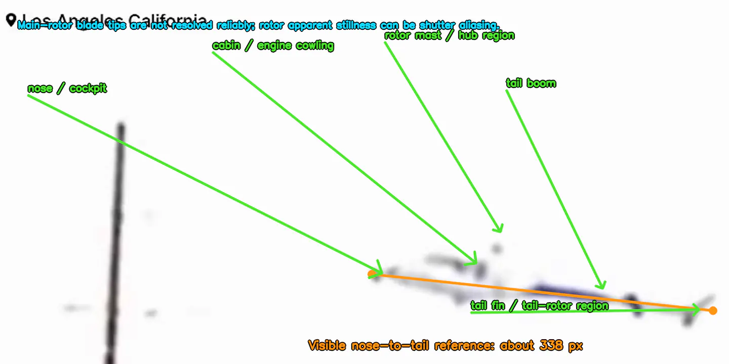
Aircraft identity, dimensions, and endpoint selectionAS 350 B2 · F34 nose (367, 271) → tail (704, 307)
The moving image maintains a coherent aircraft structure across consecutive frames. The rounded white nose, cabin and cowling, rotor-mast region, narrow dark tail boom, and tail-fin region move together as a single rigid object. This distinguishes the helicopter from compression artifacts, the stationary pole, the mountains, and vegetation.
| Published dimension | Value | Used | Reason |
|---|---|---|---|
| Rotor diameter | 35.0 ft | No | Blade-tip positions are not resolved reliably |
| Fuselage length | 35.8 ft | Yes | Matches the marked visible nose-to-tail endpoints |
| Overall D-value | 42.45 ft | No | Includes rotor geometry not represented by the marked line |
The F34 nose and tail endpoints were marked at approximately (367, 271) and (704, 307). Their straight-line separation is approximately 338.9 pixels, rounded to 338 pixels for scale conversion.
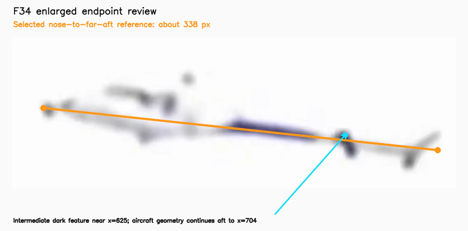
A dark vertical feature near x = 625 is an intermediate tail feature, consistent with the stabilizer or end-plate region. Fainter aircraft geometry continues to the far-aft tail assembly near x = 704 in F34 and adjacent frames. Selecting x = 625 as the aft endpoint would shorten the reference to about 260 pixels and inflate every converted speed by roughly 30 percent; it does not match the complete visible nose-to-tail extent.
04 / TECHNICAL METHODOLOGY
Every rate starts with a measured interval.
The accepted points move with the aircraft, survive a forward-backward validation, and remain distinct from the stationary background.
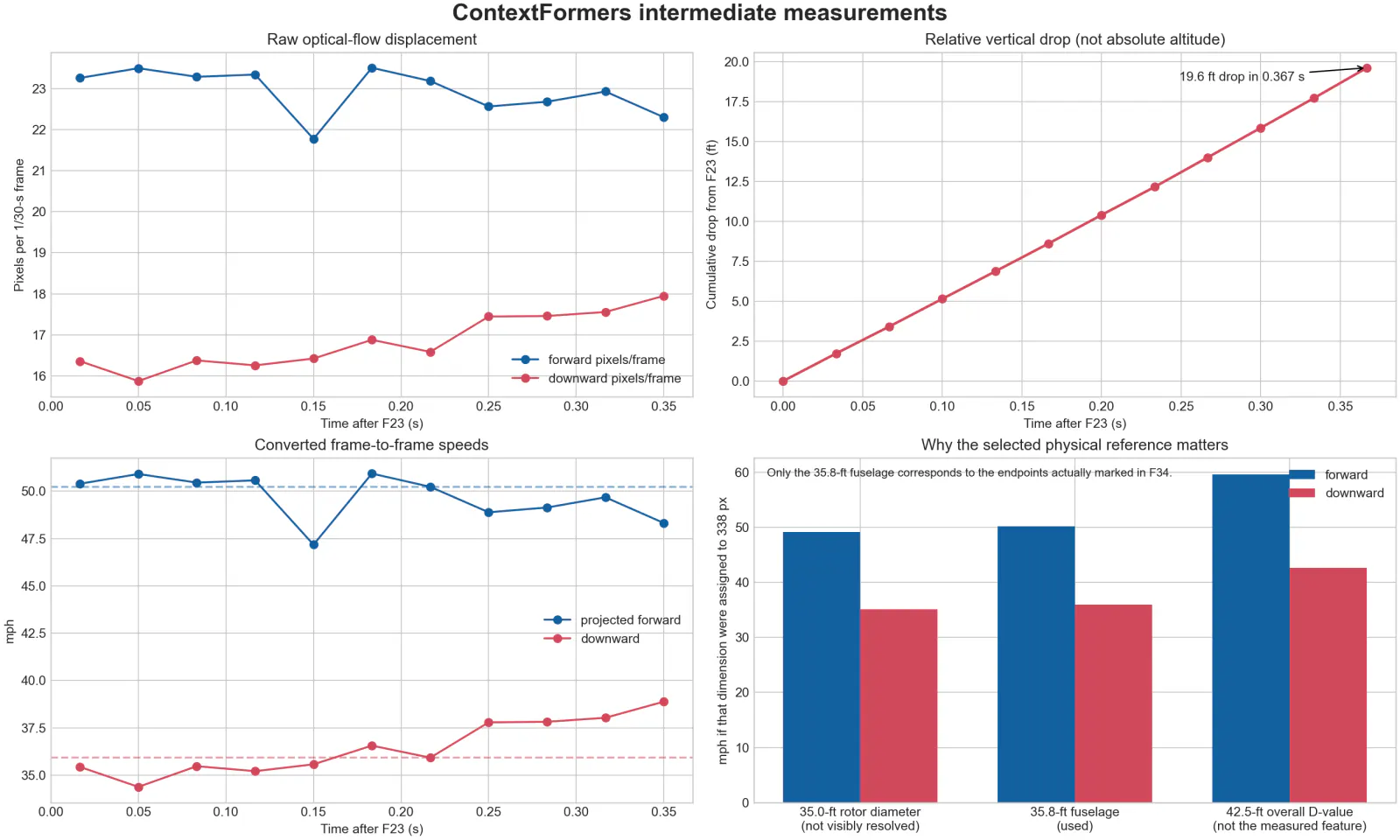
23.2 pixels per frame forward and 16.6 pixels per frame downward at 30 frames per second.
High-contrast points inside the aircraft region were tracked to the next frame using pyramidal Lucas-Kanade optical flow. Each point was also tracked backward to its starting frame. Points that failed to return within 1.5 pixels were rejected, as were stationary background points. The median displacement of the coherent moving cluster, typically 40 to 95 accepted points per interval, was used instead of any single pixel or box corner.
Detection and point-validation procedureBackground subtraction · brightness threshold · optical flow
A median empty-scene background was formed from post-pass frames. Each measurement frame was converted to grayscale and compared with that background. Pixels differing by more than 18 brightness levels were retained, isolated noise was removed, nearby changed pixels were joined, and the principal moving component in the sky region was enclosed by a diagnostic bounding box.
High-contrast points inside the aircraft region were tracked to the next frame using pyramidal Lucas-Kanade optical flow. Each point was also tracked backward to its starting frame. Points that failed to return within 1.5 pixels were rejected, as were stationary background points. The median displacement of the coherent moving cluster, typically 40 to 95 accepted points per interval, was used instead of any single pixel or box corner.
The box locates the moving aircraft and constrains feature tracking. It is not used directly as the aircraft length or velocity reference. Early boxes terminate at x = 719 because the tail is outside the frame. Later boxes degrade as the aircraft approaches the vegetation.
Complete frame-pair measurements11 intervals · F23 → F34
| Interval | dx px | dy px | Forward mph | Downward ft/min | Cumulative drop ft |
|---|---|---|---|---|---|
| F23-F24 | -23.3 | 16.4 | 50.4 | 3,118 | 1.7 |
| F24-F25 | -23.5 | 15.9 | 50.9 | 3,026 | 3.4 |
| F25-F26 | -23.3 | 16.4 | 50.5 | 3,122 | 5.1 |
| F26-F27 | -23.3 | 16.3 | 50.6 | 3,099 | 6.9 |
| F27-F28 | -21.8 | 16.4 | 47.2 | 3,130 | 8.6 |
| F28-F29 | -23.5 | 16.9 | 50.9 | 3,217 | 10.4 |
| F29-F30 | -23.2 | 16.6 | 50.2 | 3,161 | 12.2 |
| F30-F31 | -22.6 | 17.4 | 48.9 | 3,326 | 14.0 |
| F31-F32 | -22.7 | 17.5 | 49.1 | 3,328 | 15.8 |
| F32-F33 | -22.9 | 17.6 | 49.7 | 3,347 | 17.7 |
| F33-F34 | -22.3 | 17.9 | 48.3 | 3,422 | 19.6 |
Downward figures are image-plane rates. Viewing geometry can compress apparent vertical motion, so each is a lower bound rather than a measured descent rate.
Relative image-plane drop185.1 px · 19.6 ft · 0.367 s
Absolute altitude was not recovered. No calibrated ground-plane point at the helicopter's distance, camera focal calibration, or three-dimensional site geometry is available in the supplied copies. The defensible quantity is relative vertical displacement. Taking the unknown height at F23 as H0:
| Frame | Relative time | Cumulative drop px | Relative drop ft | Next descent ft/min |
|---|---|---|---|---|
| F23 | 0.000 s | 0.0 | 0.0 | 3,118 |
| F24 | 0.033 s | 16.4 | 1.7 | 3,026 |
| F25 | 0.067 s | 32.2 | 3.4 | 3,122 |
| F26 | 0.100 s | 48.6 | 5.1 | 3,099 |
| F27 | 0.133 s | 64.9 | 6.9 | 3,130 |
| F28 | 0.167 s | 81.3 | 8.6 | 3,217 |
| F29 | 0.200 s | 98.1 | 10.4 | 3,161 |
| F30 | 0.233 s | 114.7 | 12.2 | 3,326 |
| F31 | 0.267 s | 132.2 | 14.0 | 3,328 |
| F32 | 0.300 s | 149.6 | 15.8 | 3,347 |
| F33 | 0.333 s | 167.2 | 17.7 | 3,422 |
| F34 | 0.367 s | 185.1 | 19.6 | - |
Relative image-plane drop from F23, not absolute altitude loss. No absolute height above the ground is recoverable from the supplied footage.
The accumulated displacement from F23 through F34 is approximately 185 pixels, corresponding to 19.6 feet over 0.367 seconds. Dividing distance by time gives approximately 53.4 ft/s, or 3,204 ft/min, consistent with the median frame-pair result. This is relative image-plane drop, not absolute altitude loss.
Scale and velocity equationsPhysical scale · component rates · combined 2D motion
scale = 35.8 ft ÷ 338 px ≈ 0.106 ft/px
forward rate = 23.2 px/frame × 30 frame/s × 0.106 ft/px
vertical rate = 16.6 px/frame × 30 frame/s × 0.106 ft/px
combined 2D speed = √(forward² + downward²) ≈ 62 mph
Dimensional sensitivity analysisWhy rotor diameter and overall D-value are not substitutes
Assigning a different real-world dimension to the same 338-pixel marked line scales every speed linearly. This is a sensitivity demonstration, not a reason to substitute a dimension that does not match the visible endpoints.
| Dimension assigned to 338 px | Scale ft/px | Forward mph | Downward mph |
|---|---|---|---|
| 35.0-ft rotor diameter | 0.104 | 49.2 | 35.2 |
| 35.8-ft fuselage length used | 0.106 | 50.3 | 36.0 |
| 42.5-ft overall D-value | 0.126 | 59.7 | 42.7 |
A demonstration of sensitivity, not a set of alternative results. Only the 35.8-ft fuselage length matches the endpoints actually marked in F34.
Diagnostic bounding-box coordinates12 frames · source coordinate system: 720 × 720
The box locates the moving aircraft and constrains feature tracking. It is not used directly as the aircraft length or velocity reference. Early boxes terminate at x = 719 because the tail is outside the frame. Later boxes degrade as the aircraft approaches the vegetation.
| Frame | Clip time | Left x | Top y | Right x | Bottom y |
|---|---|---|---|---|---|
| F23 | 0.767 s | 611 | 61 | 719 | 122 |
| F24 | 0.800 s | 588 | 67 | 719 | 139 |
| F25 | 0.833 s | 565 | 82 | 719 | 155 |
| F26 | 0.867 s | 541 | 99 | 719 | 172 |
| F27 | 0.900 s | 518 | 117 | 719 | 188 |
| F28 | 0.933 s | 494 | 133 | 719 | 204 |
| F29 | 0.967 s | 472 | 145 | 719 | 222 |
| F30 | 1.000 s | 451 | 167 | 719 | 252 |
| F31 | 1.033 s | 427 | 183 | 719 | 269 |
| F32 | 1.067 s | 404 | 200 | 719 | 290 |
| F33 | 1.100 s | 382 | 216 | 719 | 313 |
| F34 | 1.133 s | 360 | 235 | 713 | 329 |
Boxes are diagnostic. They locate the aircraft and constrain tracking; they are not the length or velocity reference.
05 / INDEPENDENT FLIGHT-DATA COMPARISON
A separate signal. A consistency check.
Flightradar24 published granular flight data for N358TV showing an increasing descent near the end of the received data. These samples are not frame-synchronized to the supplied video. The reported altitudes are barometric values referenced to standard pressure, not height above ground.
Clean F23–F34 video sequence.
01:55:26 UTC final Flightradar24 sample.
The video's 44-kt projected forward component agrees in order of magnitude with the final reported 39-kt groundspeed. The 3,200 to 3,420 ft/min image-plane vertical result is approximately 18 to 33 percent below the reported 4,160 to 4,800 ft/min samples. Projection, perspective and sample timing can account for a material difference, so the video result is best presented as a conservative lower-bound estimate rather than a symmetric plus-or-minus range.
| UTC sample | Barometric altitude | Groundspeed | Vertical rate |
|---|---|---|---|
| 01:55:19 | 1,300 ft | not stated | -4,160 ft/min |
| 01:55:26 final | 850 ft | 39 kt | -4,800 ft/min |
External data, not frame-synchronized to the supplied video. Altitudes are barometric, referenced to standard pressure, not height above ground.
Those samples fall at roughly 6:55 p.m. PDT on 15 September, consistent with the reported time of the crash. That is a timing consistency observation; it does not synchronize the flight data to any individual video frame.
06 / EVIDENCE & INTERPRETATION
The limits are part of the result.
The footage supports projected image-plane motion. It does not establish cause, power state, pilot action, true airspeed, absolute altitude, or exact impact speed.
What the imagery supports
- Projected forward motion of approximately 50 mph (44 kt) across the image plane.
- Average image-plane descent of at least approximately 3,200 ft/min.
- A last clean vertical interval of approximately 3,420 ft/min from F33 to F34.
- Combined projected two-dimensional motion of approximately 62 mph.
What it does not establish
- True airspeed, which requires the wind vector.
- Full three-dimensional velocity or absolute height above ground.
- Exact impact speed, because the aircraft is obscured before impact.
- Engine state, rotor state, mechanical condition, pilot action, or accident cause.
Projection, uncertainty, and interpretation boundariesRead alongside the reported estimates
The clean real-time sequence supports a projected forward groundspeed of approximately 50 mph and an average image-plane descent rate of approximately 36 mph downward, equivalent to about 3,200 ft/min. The last clean frame-to-frame interval indicates about 3,420 ft/min downward. The combined projected two-dimensional flight-path speed is approximately 62 mph.
The 50 mph forward component supports a public uncertainty of approximately plus or minus 20 percent. The vertical result should instead be described as a conservative image-plane lower bound because viewing geometry can compress apparent vertical motion. The footage does not directly establish true airspeed, three-dimensional velocity, absolute altitude, or exact impact speed.
| Measurement | Estimate | Meaning |
|---|---|---|
| Projected forward component | 50 mph | 44 kt | Motion across the image plane |
| Average image-plane descent | at least 3,200 ft/min | Conservative video-based estimate |
| Last clean vertical interval | 3,420 ft/min | F33 to F34 only |
| Reported final flight data | 4,160 to 4,800 ft/min | External, not frame-synchronized |
| Combined projected speed | 62 mph | 54 kt | Vector sum of visible components |
| Uncertainty treatment | +/- 20 percent forward | Vertical stated as lower bound |
- The source files are edited social-media copies of the same camera feed, not independent viewpoints.
- Aircraft yaw can foreshorten the fuselage, which would tend to make the physical scale and true speed larger than the side-view estimate.
- Motion toward or away from the camera is not visible in the two-dimensional displacement, so the total three-dimensional speed could be higher.
- True airspeed requires the wind vector. The video yields projected ground-relative motion, not aerodynamic airspeed.
- The aircraft becomes obscured before impact. Exact impact speed and absolute height above the impact point are not visible.
- Compression, endpoint selection, lens geometry and unknown camera calibration support approximately plus or minus 20 percent for the forward component.
- The vertical component is better treated as a conservative image-plane lower bound than as a symmetric uncertainty interval.
Attitude versus path
Across the clean frames, the fuselage appears approximately level to slightly nose-up while the image-plane flight path is about 36 degrees downward. This is a visual attitude observation only; it does not by itself establish power state or accident cause.
Rotor caution
The main-rotor blade tips are not sufficiently resolved for measurement. Apparent blade stillness in individual video frames can result from shutter and frame-rate aliasing and is not evidence by itself that the rotor stopped.
07 / INCIDENT CONTEXT
The event behind the footage.
A Eurocopter AS 350 B2 flying as NewsChopper4 for NBC4 Los Angeles and Telemundo 52 came down shortly before 7:00 p.m. PDT on Tuesday 15 September 2026, in a parking lot near a self-storage facility in Chatsworth, in the San Fernando Valley, Los Angeles. It was covering an earlier, unrelated fatal collision at Nordhoff Street and De Soto Avenue in which two bus passengers were killed.
Contemporary reporting on the event, listed for reference. The incident facts stated at the top of this page are drawn from the NBC News report.
08 / RELATED COMMENTARY
A separate aviation perspective.
09 / TECHNICAL REPORT & REPRODUCIBILITY
Keep the path back to the source.
The complete measurement trail remains on this page, with the intermediate field definitions and source roles attached.
Helicopter video motion analysis
This page is the citable report. No separate download is provided.
Intermediate CSV and data provenanceField definitions and availability
The clean square copy is 720 by 720 pixels, contains 644 video frames, and runs approximately 21.467 seconds. The second copy is 910 by 512 pixels, contains 606 video frames, and runs approximately 20.200 seconds. Both report a nominal 30-frame-per-second stream.
The accompanying CSV preserves the measurement inputs and derived values for each clean frame. The most important fields are defined below so another analyst can reproduce the conversion or substitute a different physical scale.
| CSV field | Units | Definition |
|---|---|---|
| bbox x0 y0 x1 y1 | pixels | Diagnostic moving-object rectangle in source coordinates |
| dx to next | pixels | Median horizontal optical-flow displacement to the next frame |
| dy to next | pixels | Median downward optical-flow displacement to the next frame |
| cumulative drop | pixels and feet | Integrated relative descent from F23; not absolute altitude |
| forward speed | mph | Projected image-plane forward component after scale conversion |
| descent rate | ft/min | Vertical component after scale conversion |
Source videos: 51426c028307e330513d4af9f42784a1974045c8.mov; c7eaffaf811a4c8eb1fa665753bcc470.MOV.mov
References and their role in the analysisIdentity · dimensional reference · comparison · incident identification
- Aircraft registration
FAA N358TV registration inquiry. Lists N358TV as a 2004 Eurocopter AS 350 B2, serial number 3788.
- Supplied-video event match
Contemporary report reproducing the @CopterPilot crash footage. Describes the same credited regular-speed and slow-motion security-camera sequence as footage of the 15 September 2026 Chatsworth crash.
- Incident identification
Telemundo 52 report on the NewsChopper4 crash. Identifies the 15 September 2026 Chatsworth event as the NewsChopper4 crash.
- Aircraft dimensions
EASA AS350 family operational evaluation report. The AS350 family table includes the B2 variant and gives 10.93 m fuselage length, 10.69 m rotor diameter, and 12.94 m overall D-value.
- Published flight data
Flightradar24 incident report for N358TV. Reports the final altitude, groundspeed and vertical-rate samples summarized in Table 5.
- Incident facts
NBC News, 16 September 2026 — the source for the casualties, operator, location, and investigation status stated at the top of this page. Additional contemporary coverage was published by the BBC.
- Live analysis
The canonical live version of this frame-by-frame analysis, including its measurement tables, limits, and source roles.
Incident record retained from the prior report
The NTSB is leading the investigation with FAA involvement, and a preliminary report was stated as due within 30 days.
Accounts of the operator differ. NBC News reported the aircraft as operated by Angel City Air; Airbus Helicopters' own statement names Welk Aviation as the operator. This page does not attempt to resolve the difference.
Airbus Helicopters, the aircraft's manufacturer, issued a statement:
Airbus Helicopters confirms that an AS350 operated by Welk Aviation was involved in an accident on Sept. 15, in Chatsworth, California, while covering news for local television stations. We offer our condolences to the families of those who died and to everyone impacted by this accident. Airbus Helicopters is assisting in the NTSB's investigation.
The company added that more than 4,800 AS350/H125 helicopters are in service today, having accumulated around 40 million flight hours, and that it cannot comment further while the investigation is ongoing. Nothing in this statement addresses the cause of the accident.
10 / FURTHER REPORTING
Additional reporting retained for context.
These links are reference material. They are not findings of this analysis and are not presented as Zoey Tur’s commentary.
Report on the Los Angeles news-helicopter crash
Read the report BBC NewsReport on the Los Angeles helicopter crash
Read the report Los Angeles Times · 2026-09-15Report on the Metro bus and SUV collision
Covers the earlier Metro bus and SUV collision — the accident the helicopter was assigned to — not the helicopter crash.
Read the report MEAWWAirbus breaks silence after NBC4 helicopter crash as investigators examine wreckage
Aggregated reporting rather than original — the piece cites NTSB posts, KABC-TV stills, and Aviation Safety Network. It carries both the Airbus statement and Zoey Tur's assessment.
Read the report